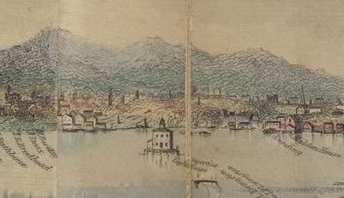
"Ulster or Saugerties" from the 1845 "Hudson River Panorama" by Wade & Croomes. Public domain. Note the original 1835 Saugerties Lighthouse at center.
Acquired from the Esopus (a northern tribe of the Lenape/Delaware nation) by Barent Cornelis Volge in the 1650s, he operated a sawmill there, supplying lumber for the Rensselaerwyck. Between 1659 and 1663 the region was rocked by a series of violent incidents between the Dutch colonists and Esopus Lenape known as "The Esopus Wars." In 1664, the Dutch surrendered their colonial claim on the region to the English, and New Netherland became New York.
In the 1710s German Palatines settled in the area north of Saugerties known as West Camp (East Camp was across the Hudson) to produce pine pitch and tar for the British Navy. The endeavor largely failed, and most of the Palatines moved on. The region continued to be exploited for lumber and a number of saw mills were established over the 18th century. The hamlet of Saugerties was officially established in 1811, though it did not get the name Saugerties until 1855. Throughout the 19th century Saugerties became an industrial hub, with an iron works established in the 1820s and a series of paper mills in the 1830s. Bluestone quarrying and shipment, brick making, and ice harvesting were other major industries in the area. Although the village had passenger steamboat service as early as the 1830s, it wasn't until the 1880s that the Saugerties and New York Steamboat Company was established in the village, providing homegrown steamboat access. Many of the paper mills, especially the Martin Cantine Paper Company (1870s-1970s) continued in operation until the mid-20th century, when industrial manufacturing declined throughout the Hudson Valley. Saugerties is also the location of the Saugerties Lighthouse. First built in 1835 to mark the entrance to the Esopus Creek, the lighthouse was replaced in 1869 with the current structure, which still stands. 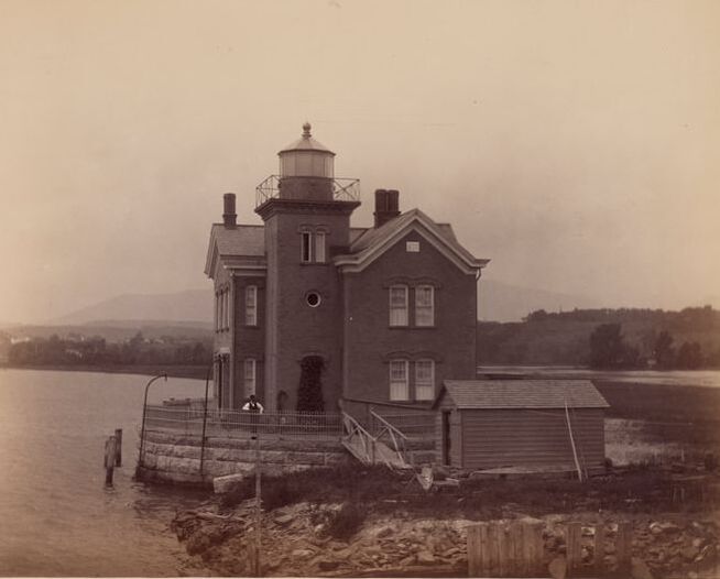
The 1869 Saugerties Lighthouse. Photo taken c. 1915. National Archives.
We stopped at the lighthouse yesterday to record some interviews, so stay tuned for a new video on the Saugerties Lighthouse coming soon! In the meantime, you can check out this documentary film from the Saugerties Lighthouse Conservancy.
See you this afternoon in Kingston!
1 Comment
It's the first day of RiverWise! Solaris and Apollonia are on their way to Catskill, and they'll pass by several lighthouses along the way up to and returning from Albany. We thought we'd share this documentary film from ABC News in the early 1980s. Thankfully, all seven of these remaining lighthouses have since been saved and many have had major restoration work done. But it's good to see how far we've come!
Can you snag a photo of Solaris or Apollonia as they go by the Rondout and Saugerties Lighthouses today?
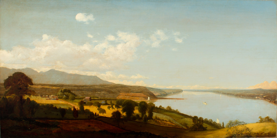 Jervis McEntee, View on the Hudson Near the Rondout, n.d., Oil on canvas, 25 x 50 in., Collection of Richard Sharp This beautiful Hudson River School painting by Rondout resident Jervis McEntee illustrates the mouth of Rondout Creek c. 1840 (note the tiny Rondout Lighthouse at the entrance to the creek - it was built in 1838). You'll note that the wide vista entrance to the creek is much different than it is today. Sloops and schooners were able to approach at a wider angle, allowing them to sail right up the creek. 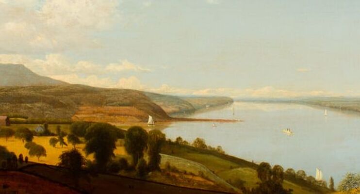 Jervis McEntee, View on the Hudson Near the Rondout, n.d., Oil on canvas, 25 x 50 in., Collection of Richard Sharp In this detail, you can better see the entrance to the creek and the lighthouse. The tall, full sails of a sloop propel it out toward the Hudson, where a steamboat and other sailing vessels go by. The two story Rondout Lighthouse looks tiny in comparison. 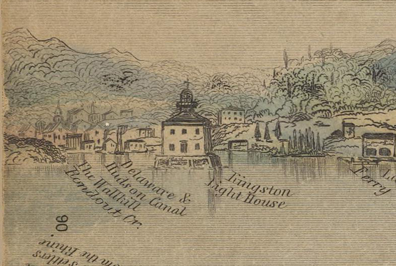 "Kingston Lighthouse," Hudson River Panorama, Wade & Croomes, 1845. Public domain. Here is another view of the Rondout Lighthouse in 1845. The perspective is not quite the same, although you'll note the ferry landing at right and the inscription "Delaware & Hudson Canal" near the lighthouse. The lighthouse was replaced in 1867 and the site moved slightly to the south. But as steamboat towing traffic increased, and the use of sloops and schooners decreased (but did not disappear) in the latter half of the 19th century, the mouth of the Rondout Creek needed "improvement." Deeper drafted vessels like larger passenger steamboats and the new screw-propelled tugboats needed a deeper river channel. Although Rondout Creek is a natural deep water port, the combination of tidal action and silt from spring floods had left the mouth of the creek shallower than desired. In 1877, the Army Corps of Engineers began a dredging and improvement project that included the construction of breakwater sea walls far out into the Hudson. 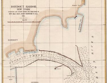 Map of improvements to Rondout Harbor, Army Corps of Engineers, 1880. Hudson River Maritime Museum collection. Where previously, shallower-drafted vessels could take a wide approach into the creek, they now were blocked by the installation of the breakwaters. Completed in 1880, with the dredge spoils dumped behind the walls, the "shallows" were now much shallower, and impassable by all but the smallest of vessels. The narrow approach made it much more difficult for sailing vessels to get in and out of the creek, and even some steamboat captains had trouble.
In addition, the 1867 lighthouse - marked on the map above - was now well behind the entrance to the creek. Red stake lights were installed at each side of the mouth and on the north curve of the breakwater walls, but boatmen complained the lighting was inadequate. In 1915 the old lighthouse was replaced with a new one, right on the north point of the breakwater walls. As Solaris and Apollonia leave Rondout on the North Hudson Voyage, we will pass along those breakwater walls, still in place and still maintained by the Army Corps of Engineers. Fair winds and bright sun - the adventure begins! |
AuthorThis Captains' Log is kept by the captains and crew of Solaris and Apollonia and staff of the Hudson River Maritime Museum. ArchivesCategories
All
|
 RSS Feed
|
Hudson River Maritime Museum
50 Rondout Landing Kingston, NY 12401 845-338-0071 fax: 845-338-0583 The Hudson River Maritime Museum is a 501(c)3 non-profit organization dedicated to the preservation and interpretation of the maritime history of the Hudson River, its tributaries, and related industries. Header image "Breakneck Ridge" courtesy Jeffrey Pang.
|
|